Drifter Lab:
Introduction:
Ocean currents are like huge rivers in the sea. They carry drifting organisms, vital dissolved chemical nutrients and pollutants with them as they flow. Surface currents affect the biological productivity of the ocean and also help determine our climate by moving hot and cold water masses around. Currents are also important for ships traveling at sea that can move with or against the flow. In this investigation we will consider one important way that scientists gather information about the location and strength of ocean currents.
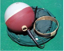
The floater at the top of the buoy sits at the surface of the water and holds an antenna for sending data to a satellite above. Drogues well below the surface cause the ocean currents to take the buoy along instead of the surface wind. The buoy also holds electronic instruments for measuring sea surface temperatures (SST), submergence, irradiance (for sunlight) and barometric pressure. At the top is another device for measuring temperature and conductivity (used to calculate salinity).
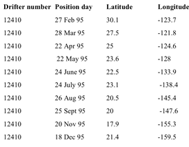
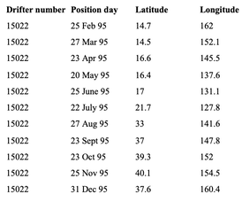
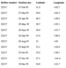
The data below are from drifter buoys in the North Pacific Ocean. Released into the ocean, the buoys float with the currents and take measurements of the water with built-in instruments. They are tracked by satellites in orbits far above Earth and transmit data several times a day.
Ocean currents are like huge rivers in the sea. They carry drifting organisms, vital dissolved chemical nutrients and pollutants with them as they flow. Surface currents affect the biological productivity of the ocean and also help determine our climate by moving hot and cold water masses around. Currents are also important for ships traveling at sea that can move with or against the flow. In this investigation we will consider one important way that scientists gather information about the location and strength of ocean currents.
The floater at the top of the buoy sits at the surface of the water and holds an antenna for sending data to a satellite above. Drogues well below the surface cause the ocean currents to take the buoy along instead of the surface wind. The buoy also holds electronic instruments for measuring sea surface temperatures (SST), submergence, irradiance (for sunlight) and barometric pressure. At the top is another device for measuring temperature and conductivity (used to calculate salinity).
The data below are from drifter buoys in the North Pacific Ocean. Released into the ocean, the buoys float with the currents and take measurements of the water with built-in instruments. They are tracked by satellites in orbits far above Earth and transmit data several times a day.
Questions #1 - 9: Use the introduction paragraph and this article (click here) to help you answer the questions:
1. Why is this instrument called a drifter?
2. How do drifters work?
3. What parameters do drifters measure/What sensors are possible?
4. Do all drifters measure sea surface temperature and ocean current velocities?
5. What is a drogue?
6. What are drifters made of?
7. How much does a drifter cost?
8. How do researchers who are interested in measuring current ensure that a drifter is moved by the current and not by wind?
9. What do you think are two advantages of using buoys and drifters over large oceanographic vessels for this type of work?
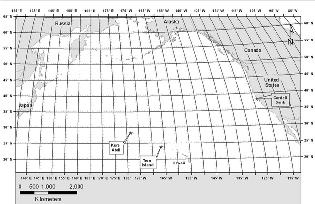
Questions 10 - 20: You will use the map below for the next question set. If you notice on this particular map, the prime meridian is not in the center, nor are the East longitudes on the right side and west longitudes on the left.
1. Why is this instrument called a drifter?
2. How do drifters work?
3. What parameters do drifters measure/What sensors are possible?
4. Do all drifters measure sea surface temperature and ocean current velocities?
5. What is a drogue?
6. What are drifters made of?
7. How much does a drifter cost?
8. How do researchers who are interested in measuring current ensure that a drifter is moved by the current and not by wind?
9. What do you think are two advantages of using buoys and drifters over large oceanographic vessels for this type of work?
Questions 10 - 20: You will use the map below for the next question set. If you notice on this particular map, the prime meridian is not in the center, nor are the East longitudes on the right side and west longitudes on the left.
10. Use the latitude and longitude data to plot each point (10 total) for the 12410 buoy. You will plot the points on the PowerPoint picture (click here). To plot each point, insert a textbox and then the number of the point (1 for Feb, 2 for Mar, 3 for Apr, etc. You will need a textbox for each number. Once you have finished plotting all the points for the 12410 buoy, save your slide and take a screenshot. Upload screenshot in the correct place in the performance task. Do not delete, you need this plotted map for more questions.
11. Repeat question 10 for drifter buoy 15022.
12. Repeat question 1o for drifter buoy 22217.
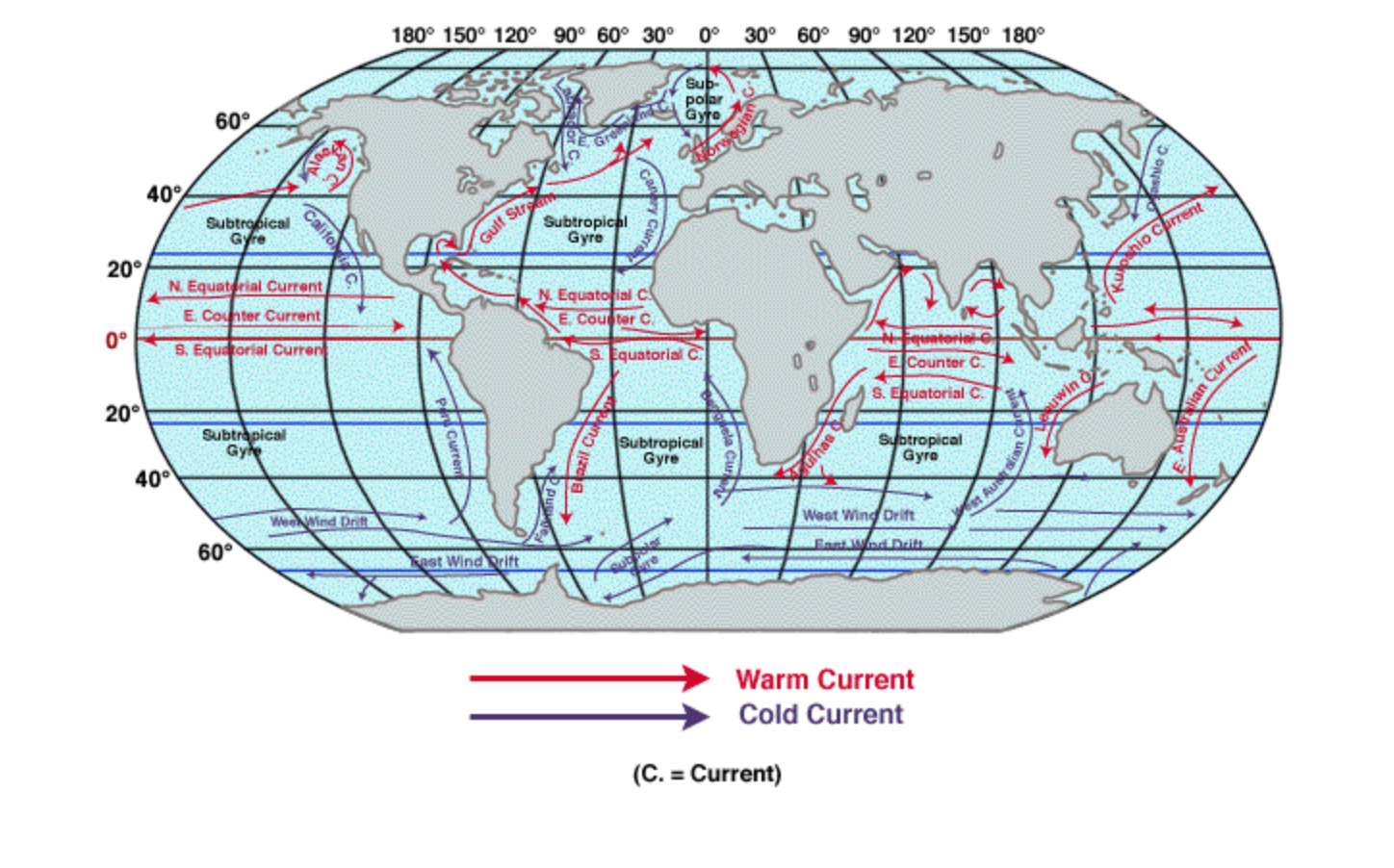
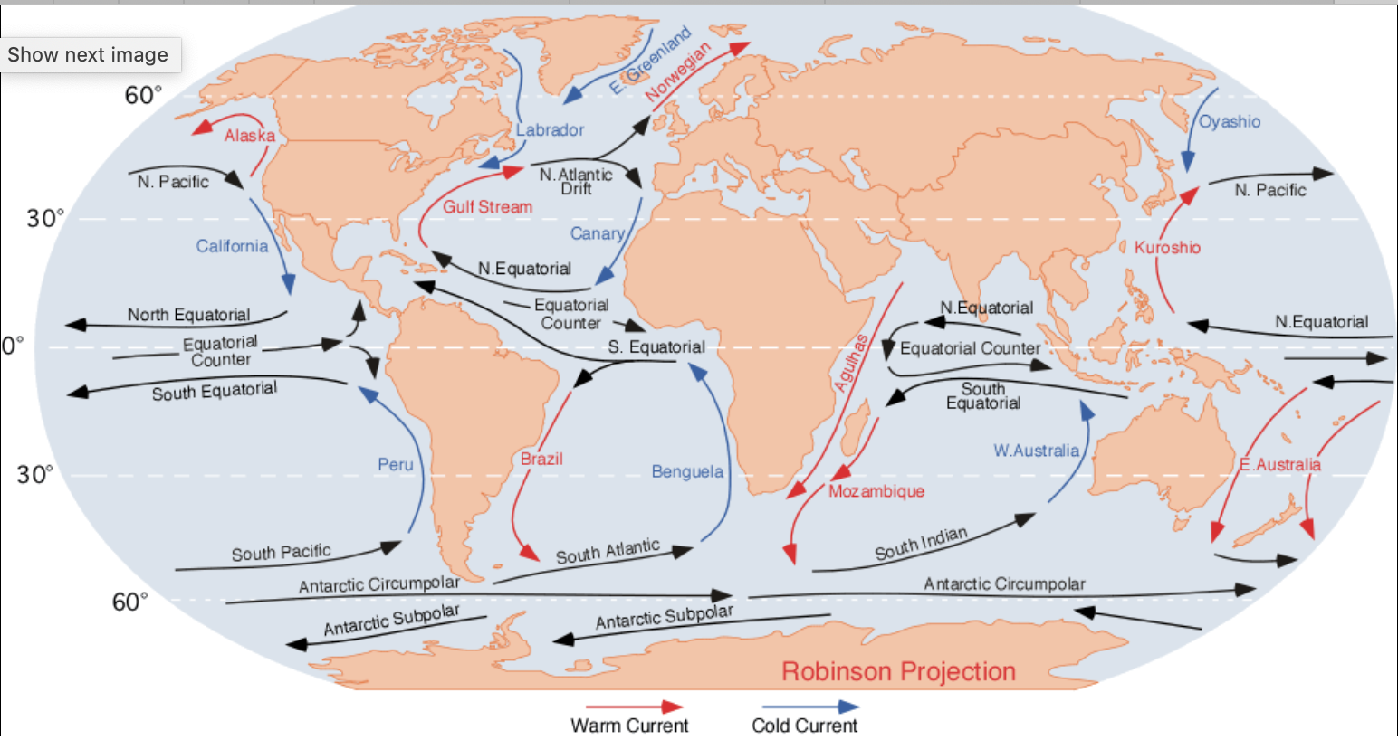
13. What are the names of the surface currents that moved the buoys whose courses you plotted? Use this map (click here) to help you locate the surface currents. For one of the buoys you may need this map (click here) to see the name. It is unclear in the other map! (a) drifter 12410 (b) drifter 15022 (c) drifter 22217
14. Drifters 15022 and 12410 are traveling in currents that are in the North Pacific gyre, a clockwise-moving current that redistributes heat in the North Pacific.
A. Drifter 22217 was released in the Gulf of Alaska. What do you notice that is different about this current from the other currents that make up the North Pacific Gyre?
B. Write a scientific explanation for why this current is rotating in the opposite direction from the other two.
15. Sometimes drifting buoys stop transmitting their data to orbiting satellites.
A. List several possibilities for why this might happen. You may want to do online research to help you.
B. How could these possibilities that you came up with be avoided?
16. Using the distance scale in the map you plotted for the 12410 buoy:
A. How far did the buoy travel?
B. Approximately how fast did the buoy travel (speed = distance/time) per day? Hint: you need to figure out how many days the buoy traveled. Speed should be in kilometers/day.
17. Using the distance scale in the map you plotted for the 15022 buoy:
A. How far did the buoy travel?
B. Approximately how fast did the buoy travel (speed = distance/time) per day? Hint: you need to figure out how many days the buoy traveled. Speed should be in kilometers/day.
18. Using the distance scale in the map you plotted for the 22217 buoy:
A. How far did the buoy travel?
B. Approximately how fast did the buoy travel (speed = distance/time) per day? Hint: you need to figure out how many days the buoy traveled. Speed should be in kilometers/day.
19. Based on your calculations, rank the three surface currents according to their speed. A = 1st, Fastest B = 2nd, Fastest C = Slowest
20. Based on your calculations for the California Current, how long would it take for plankton drifting off the coast of San Francisco to reach Santa Monica. Use google maps (click here) to determine the distance between each location to help you calculate your answer.
Questions #21 - 24: Drifter buoy 12410 is located in the Kuroshio Current off the coast of Taiwan and Japan. Here is some data from a moored (stationary buoy) located nearby at 24.122N, 122.998E.
11. Repeat question 10 for drifter buoy 15022.
12. Repeat question 1o for drifter buoy 22217.
13. What are the names of the surface currents that moved the buoys whose courses you plotted? Use this map (click here) to help you locate the surface currents. For one of the buoys you may need this map (click here) to see the name. It is unclear in the other map! (a) drifter 12410 (b) drifter 15022 (c) drifter 22217
14. Drifters 15022 and 12410 are traveling in currents that are in the North Pacific gyre, a clockwise-moving current that redistributes heat in the North Pacific.
A. Drifter 22217 was released in the Gulf of Alaska. What do you notice that is different about this current from the other currents that make up the North Pacific Gyre?
B. Write a scientific explanation for why this current is rotating in the opposite direction from the other two.
15. Sometimes drifting buoys stop transmitting their data to orbiting satellites.
A. List several possibilities for why this might happen. You may want to do online research to help you.
B. How could these possibilities that you came up with be avoided?
16. Using the distance scale in the map you plotted for the 12410 buoy:
A. How far did the buoy travel?
B. Approximately how fast did the buoy travel (speed = distance/time) per day? Hint: you need to figure out how many days the buoy traveled. Speed should be in kilometers/day.
17. Using the distance scale in the map you plotted for the 15022 buoy:
A. How far did the buoy travel?
B. Approximately how fast did the buoy travel (speed = distance/time) per day? Hint: you need to figure out how many days the buoy traveled. Speed should be in kilometers/day.
18. Using the distance scale in the map you plotted for the 22217 buoy:
A. How far did the buoy travel?
B. Approximately how fast did the buoy travel (speed = distance/time) per day? Hint: you need to figure out how many days the buoy traveled. Speed should be in kilometers/day.
19. Based on your calculations, rank the three surface currents according to their speed. A = 1st, Fastest B = 2nd, Fastest C = Slowest
20. Based on your calculations for the California Current, how long would it take for plankton drifting off the coast of San Francisco to reach Santa Monica. Use google maps (click here) to determine the distance between each location to help you calculate your answer.
Questions #21 - 24: Drifter buoy 12410 is located in the Kuroshio Current off the coast of Taiwan and Japan. Here is some data from a moored (stationary buoy) located nearby at 24.122N, 122.998E.
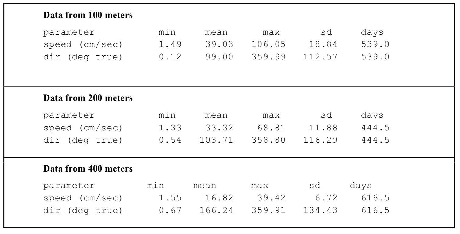
21. a) As you go deeper from 100 to 200 to 400 meters what happens to the speed of the current (you can use the mean speeds)? (b) Think back to what we have learned about the properties of water and explain why this happens.
22. Read this article on how a compass works.
A. How does a compass work?
B. What is true north?
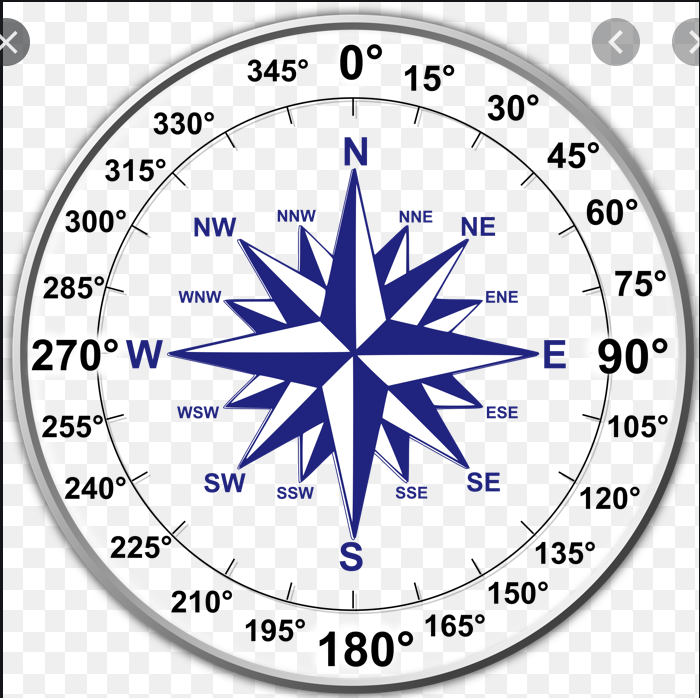
23. Look at this compass picture (click here).
A. What two degrees on a compass are true north?
B. What degree on a compass is East?
C. What degree on a compass is South?
D. What degree on a compass is West?
24. (a) As you go deeper from 100 to 200 to 400 meters what happens to the direction of the current? (use the mean dir and the compass picture (click here) to help you. (b) Explain why this happens.
22. Read this article on how a compass works.
A. How does a compass work?
B. What is true north?
23. Look at this compass picture (click here).
A. What two degrees on a compass are true north?
B. What degree on a compass is East?
C. What degree on a compass is South?
D. What degree on a compass is West?
24. (a) As you go deeper from 100 to 200 to 400 meters what happens to the direction of the current? (use the mean dir and the compass picture (click here) to help you. (b) Explain why this happens.
