Plate Tectonics Project:
Part A: Watch this Plate Tectonics video (click here) and answer the questions in your performance task.
Part B: As stated in the video, Earth's solid crust is broken into pieces called plates and each of those plates floats like boats on the liquid mantle. The liquid mantle is fluid because all the rock is melted. Since the mantle is fluid, the melted rock is always moving. The least dense melted rock rises and the more dense liquid rock is sinks. This creates a circular motion that is called convection. In fact, convection also occurs in any other fluid environment such as water (e.g. oceans, lakes, etc.) and our atmosphere. It's this movement in Earth's mantle that drives plate tectonics, which is the movement of plates! Anything that is hotter is less dense and anything cooler is more dense. So essentially hotter material (e.g. melted rock, atmospheric gases, ocean water) rises and cooler material (e.g. melted rock, atmospheric gases, and ocean water) sinks.
Step 1: In this step you will read through a Model Plate Spreading laboratory procedure (click here). Based on the procedure, draw a model of how you would set up the experiment for both a hot and cold condition while labeling all laboratory equipment included. Once finished, take photos of work and upload in correct space on performance task. In your performance task, als0 predict what would diffuse first: Food dye placed in hot or cold water! Explain your reasoning for your prediction.
Step 2: Watch this Convection video (click here) to see what would happen if food dye was placed in both a hot and cold water bath and then answer the questions below.
1. Did your observations match your expectations for either the room temperature water or the hot water? Explain why you think your observations were similar to or different than your predictions.
2. Explain how this experiment modeled plate movement.
3. Which beaker setup (room temperature or hot water) do you think modeled plate movement the best? Explain your reasoning.
4. What are the limitations to your model? If you did this experience again, how could you improve your model so it more closely represented plate movement?
Step 3: On a sheet of paper, draw a model of convection occurring in the geosphere. In your model include and label the following: Core, Mantle, Crust, Rising, Sinking, Hotter Melted Rock, Cooler Melted Rock, Less Dense, More Dense, and convection, and arrows showing the convection movement. Once finished, take photo of completed work and upload in performance task. Shrink down to a reasonable size.
Part C: This part focuses on plate boundaries. Remember that Earth's crust is broken into pieces called plates. The area where two plates meet is called a plate boundary. The major plates that form Earth's surface is shown in the picture above. The picture also shows what type of plate boundary (convergent, divergent, or transform) occurs between each major plate. If the arrows point together, that means the plate boundary is convergent (crashing into each other). If the arrows point away from each other, that means the plate boundary is divergent (moving away from each other). If the arrows are sliding past one another, that means the plate boundary is transform (sliding past one another).
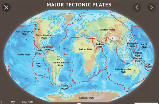
Step 1: Using the picture above, identify the following. I completed the first one for you to get you started!
A) Two plates that form a divergent boundary.
B) Two plates that form have a transform boundary.
C) Two plates that form an oceanic-oceanic plate boundary.
D) Two plates that form an oceanic-continental plate boundary.
F) Two plates that form a continental-continental plate boundary.
Steps 2: Watch the first graham cracker demonstration in this video (click here) and answer the questions below.
A) What part of Earth do the graham crackers represent?
B) What part of Earth does the marshmallow cream represent?
C) What happened to the cream when the crackers were pulled away from each other?
D) What kind of plate boundary (divergent, convergent, or transform) is represented in this part of the procedure?
E) What type of feature is produced by this movement?
F) What is the process called that creates new sea floor. Analyze this picture (click here) to help you answer.
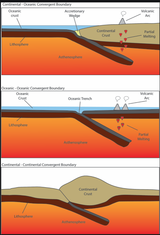
Step 3: Continue watching the second graham cracker demonstration in the video and analyze this picture (click here) to answer the questions below.
A) What are the two types of crust that are found on Earth's surface?
B) What type of plate boundary (divergent, convergent, or transform) is shown in this demonstration?
C) What are two features that can form with this plate boundary?
D) What type of crust convergence (continental and/or oceanic) are involved in mountain formation?
E) What are the three crust collisions that occur on Earth?
F) What type of crust (continental and/or oceanic) collision forms volcanoes in the ocean?
G) What type of crust (continental and/or oceanic) collision forms volcanoes on land?
H) What type of crust (continental and/or oceanic) collision causes Tsunamis?
I) Describe subduction.
J) What crust subducts when a continental and oceanic crust collide?
K) Describe how was the island of Japan formed? You may need to do additional online research to find this answer.
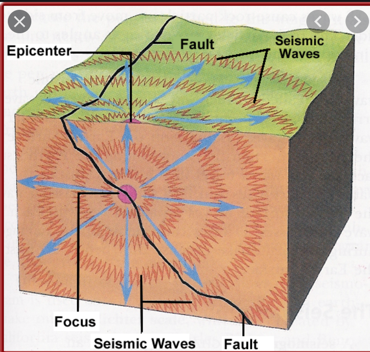
Step 4: Continue watching the third graham cracker demonstration in the same video and analyze this picture (click here) to answer the questions below.
A) What type of plate boundary (divergent, convergent or transform) is shown in the third demonstration?
B) Why is this movement often described as "horizontal sliding"?
C) As plates slide past each other, the pressure causes the plates to grind resulting in shaking and vibrations. The shaking and vibrations is known as an ___________?
D) The exact location of an Earthquake is called the _____________?
E) The point on Earth's surface right above the earthquake is called the ___________?
F) Would you expect an earthquake to be felt stronger closer to or farther away from the epicenter?
G) A transform boundary can also be referred to as a ____________ line.
H) The vibrations sent out from an earthquake in all directions are called _________________.
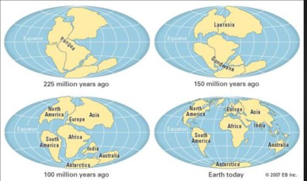
Part D: This part focuses on theory of continental drift. Continental drift is different than plate tectonics, but certainly related! Continental drift is when continents move over time. In fact, continents are moving about 1 cm every year! The reason why they move is because of plate tectonics. In this part, you will see how the continents have shifted over time to what they are today. See picture below. About 225 million years ago, all the continents were together in one giant land mass called Pangaea. The one big ocean surrounding Pangaea was called Panthalassa. About 150 million years ago, the continents started to separate into an upper and lower landmass called Laurasia and Gondwana. As the years passed, the continents began to separate even more into eventually all the continents that exist today. Scientists have evidence that continental drift exists! One example is that the shape of today's continents fit together like a puzzle. Another piece of evidence is that fossils and rock found along coastlines where scientists believe continents used to be attached are the same.
A) Two plates that form a divergent boundary.
B) Two plates that form have a transform boundary.
C) Two plates that form an oceanic-oceanic plate boundary.
D) Two plates that form an oceanic-continental plate boundary.
F) Two plates that form a continental-continental plate boundary.
Steps 2: Watch the first graham cracker demonstration in this video (click here) and answer the questions below.
A) What part of Earth do the graham crackers represent?
B) What part of Earth does the marshmallow cream represent?
C) What happened to the cream when the crackers were pulled away from each other?
D) What kind of plate boundary (divergent, convergent, or transform) is represented in this part of the procedure?
E) What type of feature is produced by this movement?
F) What is the process called that creates new sea floor. Analyze this picture (click here) to help you answer.
Step 3: Continue watching the second graham cracker demonstration in the video and analyze this picture (click here) to answer the questions below.
A) What are the two types of crust that are found on Earth's surface?
B) What type of plate boundary (divergent, convergent, or transform) is shown in this demonstration?
C) What are two features that can form with this plate boundary?
D) What type of crust convergence (continental and/or oceanic) are involved in mountain formation?
E) What are the three crust collisions that occur on Earth?
F) What type of crust (continental and/or oceanic) collision forms volcanoes in the ocean?
G) What type of crust (continental and/or oceanic) collision forms volcanoes on land?
H) What type of crust (continental and/or oceanic) collision causes Tsunamis?
I) Describe subduction.
J) What crust subducts when a continental and oceanic crust collide?
K) Describe how was the island of Japan formed? You may need to do additional online research to find this answer.
Step 4: Continue watching the third graham cracker demonstration in the same video and analyze this picture (click here) to answer the questions below.
A) What type of plate boundary (divergent, convergent or transform) is shown in the third demonstration?
B) Why is this movement often described as "horizontal sliding"?
C) As plates slide past each other, the pressure causes the plates to grind resulting in shaking and vibrations. The shaking and vibrations is known as an ___________?
D) The exact location of an Earthquake is called the _____________?
E) The point on Earth's surface right above the earthquake is called the ___________?
F) Would you expect an earthquake to be felt stronger closer to or farther away from the epicenter?
G) A transform boundary can also be referred to as a ____________ line.
H) The vibrations sent out from an earthquake in all directions are called _________________.
Part D: This part focuses on theory of continental drift. Continental drift is different than plate tectonics, but certainly related! Continental drift is when continents move over time. In fact, continents are moving about 1 cm every year! The reason why they move is because of plate tectonics. In this part, you will see how the continents have shifted over time to what they are today. See picture below. About 225 million years ago, all the continents were together in one giant land mass called Pangaea. The one big ocean surrounding Pangaea was called Panthalassa. About 150 million years ago, the continents started to separate into an upper and lower landmass called Laurasia and Gondwana. As the years passed, the continents began to separate even more into eventually all the continents that exist today. Scientists have evidence that continental drift exists! One example is that the shape of today's continents fit together like a puzzle. Another piece of evidence is that fossils and rock found along coastlines where scientists believe continents used to be attached are the same.
Step 1: Answer the questions below.
1. What are Pangaea and Panthalassa?
2. How is the theory of continental drift different than plate tectonics?
3. Why does continental drift depend on plate tectonics?
4. Describe one piece of evidence that continental drift exists.
5. Describe another piece of evidence that continental drift exists.
Step 2: You will be piecing together a puzzle of the supercontinent Pangaea based on fossil and rock evidence on the present day continents. Obtain a Continental Drift Template from your teacher or print your own copy (click here). You will need to print the pages on different sheets of paper as you will be cutting on the puzzle sheet. On the puzzle page handout, label each continent with its name. Afterward, assign a color to each type of fossil or mountain belt in the legend and color the areas of the landmasses according to the legend. Use scissors to cut along the borders of the continents. These are the approximate shape of the continents after Pangaea broke up. Place the continents on a piece of construction paper and move them around using the fossil and mountain chain evidence to match the continents together in the position they were in when they were part of Pangaea. The pieces may not fit together exactly. When you have assembled Pangaea based on the fossil and rock locations, glue the continents onto your construction paper in the shape of the supercontinent. Also glue the legend to your paper. Once finished, take photo of completed work and upload in performance task.
Step 3: Complete the Analyzing Evidence: Continental Drift Table on the template. Read the statement in each box and check whether the statement is evidence or not in the left columns and whether it supports the movements of continents in the right columns. Once finished, take photo of completed table and upload in performance task.
Step 4: Answer the questions below.
1. Which two continents have the most obvious fit of the coastlines?
2. How were the fossil symbols and mountain belts helpful in deciding where to move the continents?
3. Why don't the present shapes of the continents fit perfectly into a supercontinent?
4. Which fossil occurs on the most landmasses? What does this suggest about when these particular continents broke up?
