World Map Project:

Step 1: Our planet Earth is constantly changing. Some areas are being created by volcanic action and rifts in the earth, while other areas are being destroyed by earthquakes and subduction. During this school year, we will discuss many different events, which occur throughout various regions of the world. The purpose of this activity is to orient yourself with current landmasses and marine environment locations on Earth. You will accurately draw latitude and longitude lines on a map of the world, label different land and water masses, and use your map to find any given set of coordinates (where latitude and longitude meet). The map in this activity is a representation of Earth in its present form. Before we start the map, we need to learn about latitude and longitude locations. Read this article (click here) and complete the activity below.
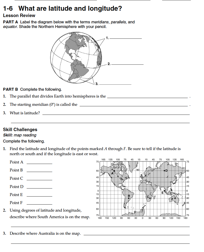
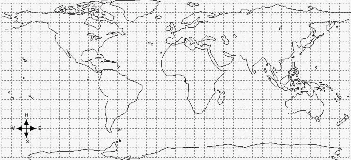
Step 2: In this step, you will be creating a world map of the current landmasses and marine environments listed below. To do this activity, you will need a World Map Template (click here) or obtain a copy from your teacher. The copy the teacher will give you will be on a 11 x 17 inch paper. To have enough room, it is recommended, but not mandatory that if you print at home, you do so on the same size paper. You will also need a pencil/pen, yellow and pink highlighter, green or brown colored pencil, straight edge like a ruler or edge of a binder/textbook, and Internet. Follow the sequence of the procedure and do not skip a step before starting another! Once finished with map, take photo of work and upload in your performance task. Shrink up or down to a reasonable size so it fits on at least one page of the performance task.
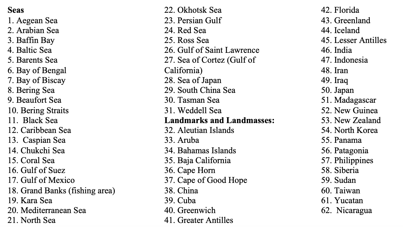
1. Create a key on the bottom of your front page. Basically copy what is listed in the picture below. Include all the seas, landmarks, and landmasses with their corresponding numbers.
2. Research where each of the five major oceans are located. Write their NAMES (e.g. Pacific Ocean) on the map. Using a colored pencil (Not pen), lightly shade in the oceans.
3. Quickly label where each of the continents are located. If you don't remember, refer back to your World Oceans Project. Write their NAMES (e.g. North American) on the map. Using a colored pencil (Not Pen) lightly shade in the continents a green or brown color.
4. Identify where each SEA and LANDMARK/LANDMASSES listed in the key are located on the map labeling with their corresponding NUMBER, not their name (there’s not enough room) using ink/pen.
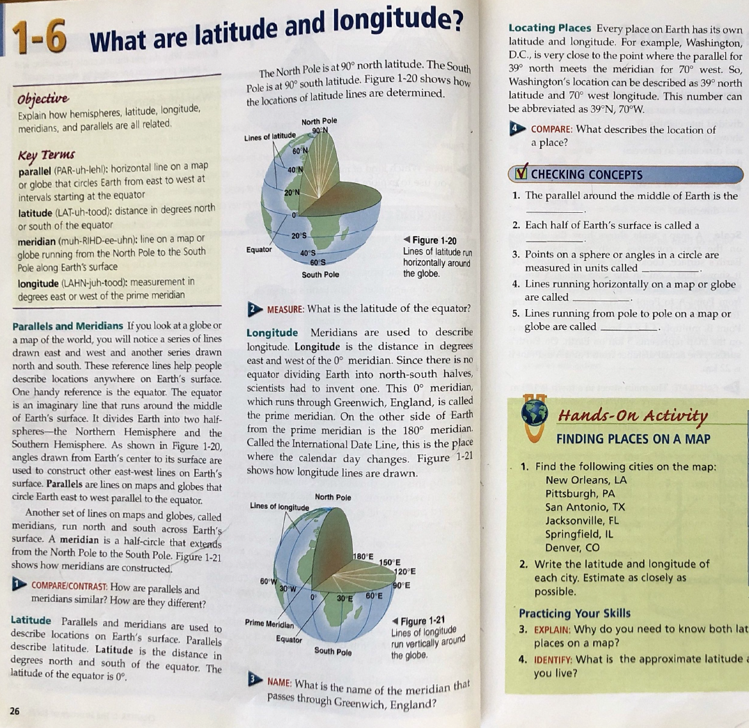
5. Draw the EQUATOR line, it passes through the mouth of the Amazon River and goes through the middle of the island of Borneo in Indonesia. Go online to help you determine where the equator is located. Don’t guess! THE LINE LOCATED IN THE MIDDLE OF THE MAP MAY NOT BE THE EQUATOR. Highlight the equator with a yellow highlighter and label it 0 degrees. See picture above for a reference as to how to label latitudes and longitudes.
6. Label each 10° increment latitude line both north and south of the equator. Always write N (for north) and S (for South) after the number (e.g. 20°N) indicating if the latitude line is located above or below the equator.
7. Draw the PRIME MERIDIAN (O° longitude). The Prime meridian runs through the Royal Naval Observatory in Greenwich, England, and cuts off the ear of Africa. Go online to help you determine where the prime meridian is located. Once again, DON'T GUESS. Highlight the Prime Meridian with a yellow highlighter.
8. Label each 10° increment longitude line both west and east of the prime meridian. Always write west or east after the number (e.g. 20°W) indicating if the longitude line is on the right or left of the prime meridian. Use the picture above as a reference. Please note that the picture above is labeling each increment by 15 degrees. For your map, your increments are 10 degrees!
9. Locate and draw the Tropic of Cancer and the Tropic of Capricorn using dashed lines with a pink highlighter. Look online to determine what latitude they fall on fall!
10. Test the accuracy of your map by asking a friend to tell you the LATITUDE (North or South) AND LONGITUDE (West or East) for one of the oceans/seas or landmasses labeled on your map. You should both have the same answers!
1. Create a key on the bottom of your front page. Basically copy what is listed in the picture below. Include all the seas, landmarks, and landmasses with their corresponding numbers.
2. Research where each of the five major oceans are located. Write their NAMES (e.g. Pacific Ocean) on the map. Using a colored pencil (Not pen), lightly shade in the oceans.
3. Quickly label where each of the continents are located. If you don't remember, refer back to your World Oceans Project. Write their NAMES (e.g. North American) on the map. Using a colored pencil (Not Pen) lightly shade in the continents a green or brown color.
4. Identify where each SEA and LANDMARK/LANDMASSES listed in the key are located on the map labeling with their corresponding NUMBER, not their name (there’s not enough room) using ink/pen.
5. Draw the EQUATOR line, it passes through the mouth of the Amazon River and goes through the middle of the island of Borneo in Indonesia. Go online to help you determine where the equator is located. Don’t guess! THE LINE LOCATED IN THE MIDDLE OF THE MAP MAY NOT BE THE EQUATOR. Highlight the equator with a yellow highlighter and label it 0 degrees. See picture above for a reference as to how to label latitudes and longitudes.
6. Label each 10° increment latitude line both north and south of the equator. Always write N (for north) and S (for South) after the number (e.g. 20°N) indicating if the latitude line is located above or below the equator.
7. Draw the PRIME MERIDIAN (O° longitude). The Prime meridian runs through the Royal Naval Observatory in Greenwich, England, and cuts off the ear of Africa. Go online to help you determine where the prime meridian is located. Once again, DON'T GUESS. Highlight the Prime Meridian with a yellow highlighter.
8. Label each 10° increment longitude line both west and east of the prime meridian. Always write west or east after the number (e.g. 20°W) indicating if the longitude line is on the right or left of the prime meridian. Use the picture above as a reference. Please note that the picture above is labeling each increment by 15 degrees. For your map, your increments are 10 degrees!
9. Locate and draw the Tropic of Cancer and the Tropic of Capricorn using dashed lines with a pink highlighter. Look online to determine what latitude they fall on fall!
10. Test the accuracy of your map by asking a friend to tell you the LATITUDE (North or South) AND LONGITUDE (West or East) for one of the oceans/seas or landmasses labeled on your map. You should both have the same answers!
